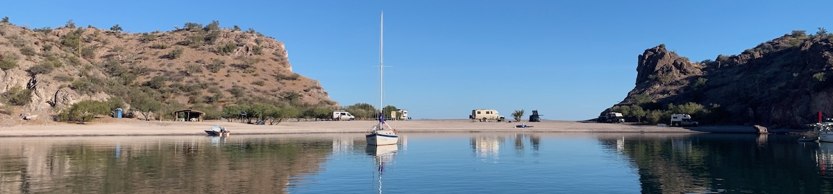
At last we have arrived, it took a few days longer than expected due to a very active monsoon season. The Malaysian and Thai official weather sites said we should keep off the sea until next Wednesday, however their forecasts are for the high seas, and looking at the GRIB files I get, which show the expected wind, it didn’t look that bad inshore. However when we left yesterday morning, and cleared the headland we where being tossed all over the place and only able to make about 2 knots into the wind and waves, we could have hoisted the sails, but there were squalls all along the horizon, so we just did a U-turn and had a quiet day on the boat back at anchor. Big squalls blew through all day making me feel better about our decision to stay
Here is a track of our movements at anchor, you can see from the scale we need a good 200ft around us, but we don’t get that luxury, boats pile in all around and if they don’t swing the same as us, then we get quite close.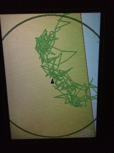
So this morning we checked the weather, the Thai forecast was a bit less doom-laden, and the sun was shining. I also realised we don’t need to go to the south of the island which is where you have to check in, I could go to the north and then get a taxi down south with the boats papers and get us checked in. This is the job first thing tomorrow so we can get visas and custom clearance. This fact made it easier to plot a course, with the wind going from the west to more southerly we could make Ao Po Grand Marina in one tack, close hauled. Also I knew the weather was going to improve and the sea state calm as we entered into Ao Phang Nga bay, which protects us from the big waves coming in from the storms out in the Andaman sea. So if we could get out of Phi Phi ok then ‘Things can only get better’. And so it was. Track below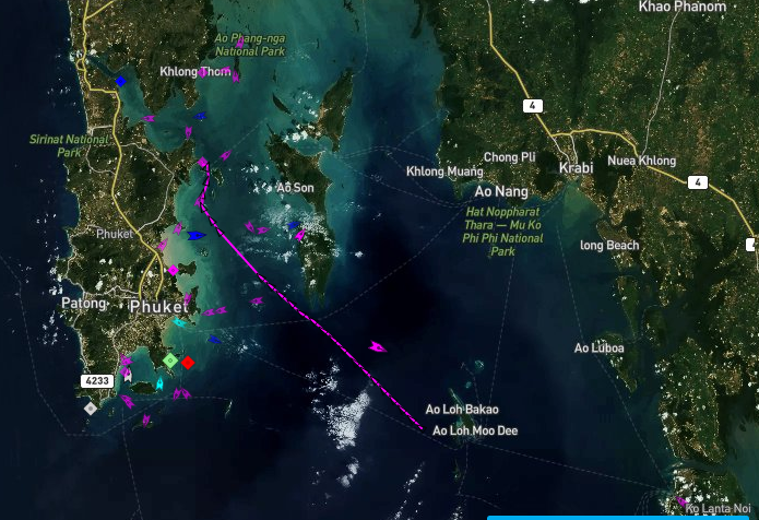
 Thanks to Marine traffic for the track, the points were generated by my iPhone sending AIS updates in, you can see the bit where the battery went flat 🙁 I did have the track on the Navionics app, but that keeps crashing and losing the track. Considering this is my main chart plotter, that’s a little concerning. However it’s not that accurate anyway, paper charts are rubbish here so I use google earth overlays in OpenCPN, along with Navionics and the chart in the cockpit plotter, which came with the boat. It’s important to keep a good lookout anyway.
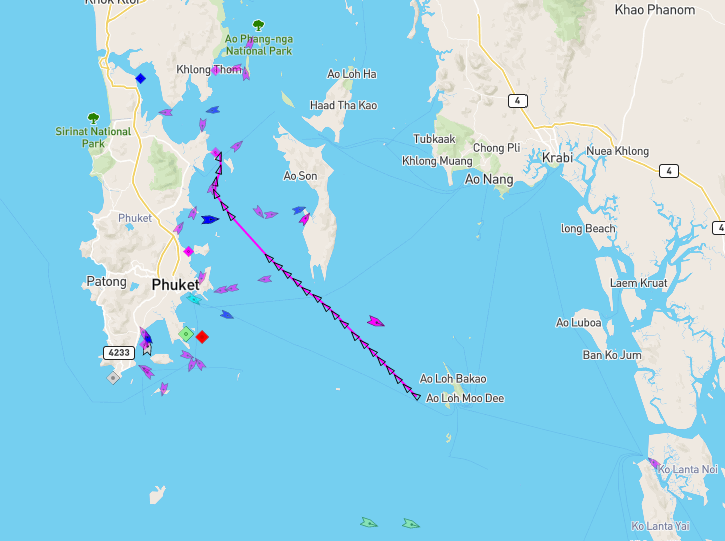
So with a reef in the main, and 75% Yankee, and 99%Staysail up, we romped along close hauled making between 5 and 7 knots all the way, which for those of you who don’t sail, is quite fast for a big heavy boat like this. With each hour the sea calmed more and the sky got sunnier. No rain all the way until the last minute as we approached the marina. I had furled up the staysail, and we were on a reach heading N between the two islands you can see on the map below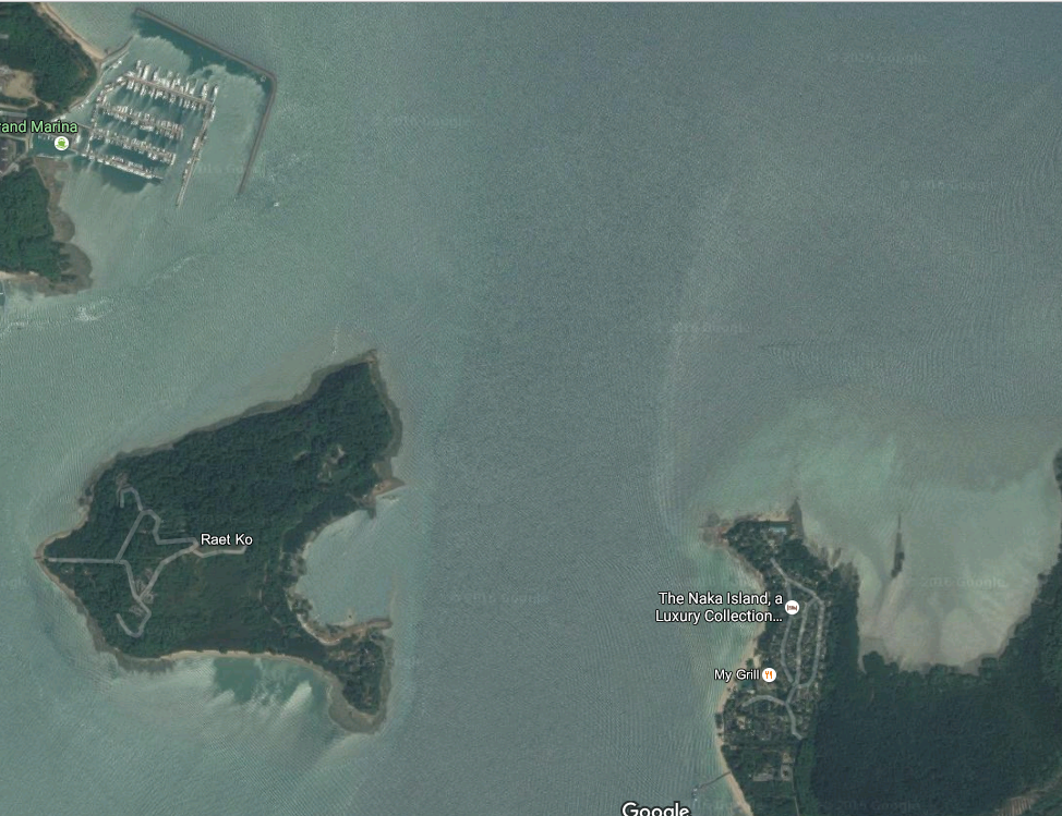 The gap isn’t big here, also a good chunk of the coast on the left island has a large construction, like a fish farm, or possible foundations for a new marina. Anyway a massive squall popped over the coast on our left, there was no warning and it was one of the worst I have seen, 0 – 35 knts in seconds, I had no time to reduce sail and I knew I was going to be overpowered with the main and the headsail out and the wind from behind I worried I would be driven into one of the two islands, a few seconds later I was drenched, and visibility dropped. I tried to run with the wind, but it was too much so I was able to spill some wind by steering up to the fish farm, letting the main flap a lot and that slowed me down enough to steer safely, then dropping back into the squall for a minute and then heading up again. I quite enjoyed it actually, it’s much more fun than back home, where if this sort of wind starts in the Irish sea, it could be like that and get worse for hours,maybe days, plus it’s usually bloody cold there. Here I knew this would be over in minutes so just had to make the most of it. Sure enough the whole show only lasted 5 minutes, before the wind dropped a lot, but the rain increased and I lost all visibility. This is where the binnacle compass comes into it’s own. I just steered 20 deg knowing that would get me clear of land. A few minutes later and it’s very calm. so we put the fenders out, brought a mooring line I had just setup back on board, started the engine, dropped the sails and into the marina.
This is a lovely spot, and now we have power I have been able to get my macbook charged back up, hence this blog post, although it took a while, the boat was tripping the marina supply, this is down to the second AC outlet circuit on the boat. I presume somewhere water got into the sockets, which wont be hard to find, but it’s worrying that water is getting in at all.
Kathy will no doubt write a much more interesting blog shortly. In the meantime here’s some pics.
Paul C